PLEASE CONSIDER CAREFULLY ANY RESPONSES
TO THIS POST THAT WILL BE DIRECTED TO THE WHOLE LIST.
PERSONAL OR PRIVATE COMMENTS SHOULD BE DIRECTED TO
[log in to unmask]
Dear Bruce and Colleagues,
Such an event is becoming all-too-common world-wide. There are
three obvious reasons for outcrop desecration:
1. Commercial gain by individuals and companies,
Beautiful/rare/perfect minerals, mineral aggregate, fossils, and rock
structures are always at risk. The worst example of this with which I
am familiar is the removal of slabs of wonderfully weathered and
etched slabs of lower Carboniferous fossiliferous carbonates from Hook
Head, Co Wexford, Ireland. This is quite shocking and inexcusable and
should be made illegal; the US has more advanced laws in this regard
than any other nation.
2. The collection of aesthetically-pleasing, beautiful, and
teaching specimens by individuals, departments, and Museums. I suspect
that most of us have done this to some extent (I certainly have) There
are "admirable" reasons for the collecting but little
thought given to the fact that future generations will not have the
intellectual and aesthetic benefit of seeing the great classic
outcrops of the world in their pristine condition.
3. The collection of specimens for valid research reasons. If
geology is to progress, specimens have to be collected for laboratory
analysis. However, classic, beautiful outcrops need not be wrecked. A
particular example is the drilling of the wonderfully washed and
polished rocks of the Komati river section in the Barberton Mountain
Land in South Africa. Another is the drilling of the KT boundary
section in Woodside Creek in the Seaward Kaikouras in the South Island
of New Zealand. Te perpetrators of these drillings are known.
Generally, adjacent outcrops can be sampled even with rock saws and
drills and satisfactory samples can be collected. Commonly, people
want the quick, easy, lazy, and dirty solution, and attack the best,
most easily-accessible and exposed outcrops.
Collecting should be discouraged by Societies, and University
geology departments. The GSA should put out a directive.Most of it is
unnecessary. Knocking off a bit of rock, and collecting the odd fossil
or mineral is, perhaps , acceptable provided that classic outcrops are
not ruined but the use of a rock saw or rock drill on "top"
outcrops is unacceptable and must, somehow, be banned. Exposure of
perpetrators, expulsion from professional societies and organizations,
and massive fines are minimal "solutions". The rock saw
vandalism of the Bartlett Wash deformation bands is surely
by someone or a group doing research on deformation bands; he, she, or
they should not be too hard to trace. The Federal and State
Authorities should pursue this vigorously and prosecute to the full
extent of Federal and State Law. The geological profession needs to be
vigilant in preventing, reporting, and exposing outcrop
vandalism.
Best wishes,
John Dewey
Colleagues,
On a field trip to Bartlett Wash north of Moab, SE Utah last week I
came across a particularly sad case of geo-vandalism.
The exact location of the affected outcrop is: 38° 43' 00.09"
N 109° 47' 17.85" W. Many of you may have visited this
spectacular location on university or industry field trips, or for
your own research purposes. The location of the exposure is on a splay
off the main Moab Fault, and it illustrates many aspects of brittle
deformation and fluid flow, as well as some un-paralled exposures of
aeolian dune sets in the Slickrock member of the Entrada Formation.
It's a truly world-class field location and has been used in a number
of publications and texts, including the following figure in Haakon
Fossen's structural geology textbook.
Figure 8.11 in Structural Geology by Haakon Fossen (Cambridge
University Press)
One of the key aspects of this location is the 100% exposure of
deformation bands in the footwall of the fault and their relationship
to fluid flow. Students can measure and plot deformation band density
in the footwall of the fault and it's a great location to discuss
their influence of fluid migration. Anyway, this (formally) pristine
outcrop is now missing a few of the deformation bands in Haakon's
photo due to some mindless geo-vandalism (see below)
Photo taken by Roy Luck on September 29th 2011.......note the rock
powder spread around the outcrop showing evidence of very recent
cutting
I really hope this geo-vandalism wasn't undertaken by a geological
research group, but I'm finding it hard to think why anyone else who
would go to the effort of lugging a rock saw up on to the outcrop in
order to remove samples of deformation bands from this fantastic
location.
I've discovered that the damage to this outcrop was first reported to
the BLM (Bureau of Land Management......the Federal Gov agency that
has responsibility for the Bartlett Wash recreation area) on September
29th 2011 by a group visiting the location on a field trip.
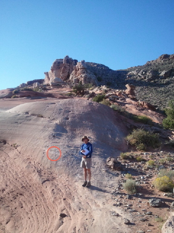
As chance would have it, I can tie down the date that this
geo-vandalism occurred to a 3 day window (Sept 26th, 27th or 28th
2011)......here's a photograph of the same outcrop at 520pm on
September 25th 2011, when I was at Bartlett Wash with a field
class.
Me, rabbiting on about faults and deformation bands 523pm Sept 25th
2011. Pristine outcrop behind me with location of geo-vadalism shown
by red circle.
Using a rocksaw to extract samples from BLM lands is illegal under
federal law (sampling of an intact rock body requires a permit). The
BLM office in Moab did not approve of any permits for sampling at
Bartlett Wash (nor, they assure me, would they have done) and once
informed of the damage notified the law enforcement agencies in Moab
about this criminal act. Beyond being a crime however, this wanton
vandalism of such a stunning outcrop is utterly mid-boggling to me.
Again, I don't know who did this, I don't know that it was a
geologist, but again I'm struggling to think who else would go to the
effort of extracting deformations bands from an outcrop in such a
manner.
So, what to do?
I'm sure many of you have seen examples of such outcrop desecration in
other areas and on some of your favourite locations. I know for
example that this has been a problem in the UK and the Geol Soc has an
active campaign to stop it.
We know that this particular act of geo-vandalism took place on either
September 26, 27 or 28th 2011.
If you have any information on who may have committed this crime you
can contact me at [log in to unmask], or contact the BLM office in
Moab directly. The geologist there is Becky Doolittle
([log in to unmask]).....she will pass on any information to the law
enforcement agencies.
Many thanks
Bruce
PLEASE CONSIDER CAREFULLY ANY RESPONSES TO THIS POST THAT WILL BE
DIRECTED TO THE WHOLE LIST.
PERSONAL OR PRIVATE COMMENTS SHOULD BE DIRECTED TO
[log in to unmask]
Dr Bruce Trudgill
Associate Professor
Department of Geology and Geological Engineering
Colorado School of Mines
Golden, Colorado 80401-1887
USA
Telephone: (1) 303 273-3883
FAX: (1) 303 273-3859
Dr Bruce Trudgill
Associate Professor
Department of Geology and Geological Engineering
Colorado School of Mines
Golden, Colorado 80401-1887
USA
Telephone: (1) 303 273-3883
FAX: (1) 303 273-3859
PLEASE CONSIDER CAREFULLY ANY
RESPONSES TO THIS POST THAT WILL BE DIRECTED TO THE WHOLE
LIST.
PERSONAL OR PRIVATE COMMENTS SHOULD BE
DIRECTED TO [log in to unmask]
Colleagues,
On a field trip to Bartlett Wash north of
Moab, SE Utah last week I came across a particularly sad case of
geo-vandalism.
The exact location of the affected
outcrop is: 38° 43' 00.09" N 109° 47' 17.85"
W. Many of you may have visited this spectacular location on
university or industry field trips, or for your own research purposes.
The location of the exposure is on a splay off the main Moab Fault,
and it illustrates many aspects of brittle deformation and fluid flow,
as well as some un-paralled exposures of aeolian dune sets in the
Slickrock member of the Entrada Formation. It's a truly world-class
field location and has been used in a number of publications and
texts, including the following figure in Haakon Fossen's structural
geology textbook.

Figure 8.11 in Structural Geology by
Haakon Fossen (Cambridge University Press)
One of the key aspects of this location
is the 100% exposure of deformation bands in the footwall of the fault
and their relationship to fluid flow. Students can measure and plot
deformation band density in the footwall of the fault and it's a great
location to discuss their influence of fluid migration. Anyway,
this (formally) pristine outcrop is now missing a few of the
deformation bands in Haakon's photo due to some mindless geo-vandalism
(see below)

Photo taken by Roy Luck on September
29th 2011.......note the rock powder spread around the outcrop showing
evidence of very recent cutting
I really hope this geo-vandalism wasn't
undertaken by a geological research group, but I'm finding it hard to
think why anyone else who would go to the effort of lugging a rock saw
up on to the outcrop in order to remove samples of deformation bands
from this fantastic location.
I've discovered that the damage to this
outcrop was first reported to the BLM (Bureau of Land
Management......the Federal Gov agency that has responsibility for the
Bartlett Wash recreation area) on September 29th 2011 by a group
visiting the location on a field trip.
As chance would have it, I can tie down
the date that this geo-vandalism occurred to a 3 day window (Sept
26th, 27th or 28th 2011)......here's a photograph of the same outcrop
at 520pm on September 25th 2011, when I was at Bartlett Wash with a
field class.
Me, rabbiting on about faults and
deformation bands 523pm Sept 25th 2011. Pristine outcrop behind me
with location of geo-vadalism shown by red circle.
Using a rocksaw to extract samples from
BLM lands is illegal under federal law (sampling of an intact rock
body requires a permit). The BLM office in Moab did not approve of any
permits for sampling at Bartlett Wash (nor, they assure me, would they
have done) and once informed of the damage notified the law
enforcement agencies in Moab about this criminal act. Beyond being a
crime however, this wanton vandalism of such a stunning outcrop is
utterly mid-boggling to me. Again, I don't know who did this, I don't
know that it was a geologist, but again I'm struggling to think who
else would go to the effort of extracting deformations bands from an
outcrop in such a manner.
So, what to do?
I'm sure many of you have seen examples
of such outcrop desecration in other areas and on some of your
favourite locations. I know for example that this has been a problem
in the UK and the Geol Soc has an active campaign to stop
it.
We know that this particular act of
geo-vandalism took place on either September 26, 27 or 28th
2011.
If you have any information on who may
have committed this crime you can contact me at [log in to unmask], or contact the BLM
office in Moab directly. The geologist there is Becky Doolittle ([log in to unmask]).....she will pass on any
information to the law enforcement agencies.
Many thanks
Bruce
PLEASE CONSIDER CAREFULLY ANY
RESPONSES TO THIS POST THAT WILL BE DIRECTED TO THE WHOLE
LIST.
PERSONAL OR PRIVATE COMMENTS SHOULD BE
DIRECTED TO [log in to unmask]
Dr Bruce Trudgill
Associate Professor
Department of Geology and Geological
Engineering
Colorado School of Mines
Golden, Colorado 80401-1887
USA
Telephone: (1) 303 273-3883
FAX: (1) 303 273-3859
Dr Bruce Trudgill
Associate Professor
Department of Geology and Geological
Engineering
Colorado School of Mines
Golden, Colorado 80401-1887
USA
Telephone: (1) 303 273-3883
FAX: (1) 303 273-3859
--
Please note that my email address has changed to:
[log in to unmask]
Prof. John F. Dewey FRS, M.R.I.A., FAA, Mem. Acad. Eur., Mem.
US Nat. Acad. Sci., Distinguished Emeritus Professor University of
California, Emeritus Professor and Supernumerary Fellow, University
College Oxford.
Sherwood Lodge,
93 Bagley Wood Road,
Kennington,
Oxford OX1 5NA,
England, UK
University College,
High Street,
Oxford OX1 4BH
Telephone Nos:
011 44 (0)1865 735525 (home Oxford)
011 44 (0)1865 276792 (University College Oxford)