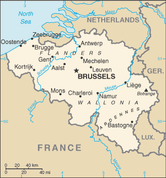
burkina faso with cote d ivoire & ghana
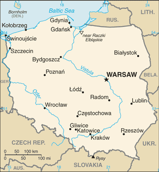
049 bfcigh notional & de facto tricountry conjunction since independence in 1960 of haute volta viz the eventual burkina faso succeeding binational frgb colonial trijunction created by 1947 french reorganization possibly restoring administrative limits dating from 1903 but fixed in any case per 1905 frgb note on thalweg of black volta aka mouhoun river & said to lie in roughly n9d29m30s 2w41 based on possibly inconsistent french colonial map evidence in the absence of demarcation or any certain official acts or decrees
& perhaps most tellingly this 1979 ibs study reports relevant ign map indicates a stream confluence location for the tripoint http://www.law.fsu.edu/library/collection/LimitsinSeas/IBS169.pdf while it is noteworthy that a minor right bank tributary does appear to emerge as described just below saru landing at around n9d29m8s per recent aerial photo
ibs 138 169
burkina faso with cote d ivoire & mali
050 bfciml notional & de facto tricountry conjunction since independence in 1960 of haute volta viz the eventual burkina faso succeeding indefinite french administrative trijunction established apparently in 1947 if it was not determined in 1919 at confluence of intermittent danboro & perennial zagoundouba headstreams of leraba occidentale based only on french colonial map evidence in the absence of demarcation or any certain official acts or decrees in roughly 10n26 5w31 tho whether the tripoint is situated at median or thalweg junction remains in doubt
burkina faso with ghana & togo
051 bfghtg tricountry point since independence of togo in 1960 first briefly as frghtg succeeding binational jurisdictional tripoint created by the frgb partition of togoland in 1916 up to the defr boundary as delimited in 1912 & evidently situated on median line of kulutamsi river beside frgb pillar 148 dating from 1929 or earlier tho the pillar itself has also been cited if perhaps in error as the direct marker of the tripoint
ibs 126 128
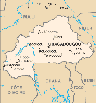
burkina faso with mali & niger
052 bfmlne tricountry point since independence in 1960 of haute volta the eventual burkina faso succeeding french administrative tripoint dating from 1919 & determined by 1986 icj bfml judgment to be situated in the heights of ngouma about 3km north of kabia ford or at n14d54m48s e0d14m39s in the unknown datum of the 1960 ign map referenced by the court & later reported to have been demarcated by bf&ne if not also by bf&ml per the court order
bulgaria greece macedonia
053 bggrmk tricountry point as bggryu til independence of macedonia in 1991 created ex novo either in 1913 by treaty of bucharest which appears to have imperfectly distributed the ottoman vilayet of salonica among its 3 occupiers leaving the exact location of the original bggrrs trijunction in some doubt or else in 1919 by treaty of neuilly sur seine which transferred strumica from bulgaria to the serb croat slovene state & put an end to any doubt by changing at least the trifinial configuration if not also the actual location situated on belasica ridge & finally fixed with certainty at tumba summit elev1881m in n41d20m18s73 e22d55m39s33 wgs84 where it had already been demarcated in 1913 unilaterally by bulgaria if not also presciently by grrs marker number 1 & was later assimilated with or joined by other demarcations also numbered 1 in their respective series
ibs 56 69 130
bulgaria greece turkey
054 bggrtr tricountry point created ex novo by lausanne treaty of 1923 resolving 1922 armistice of mudanya & first demarcated remotely in 1926 on median line of main channel of maritsa river just south of an island named kavak ada or evros alpha but displaced ca1953 when bulgaria & greece divided the western half of the island a few hundred meters northward to a location near mid island known as point 1 & situated in roughly n41d42m40s e26d21m28s wgs84
ibs 41 49 56
bulgaria macedonia serbia
055 bgmkrs tricountry point since independence of macedonia in 1991 succeeding 1945 yugoslav interstate border terminus at 1919 bgyu international boundary positionally fixed or reaffirmed by 2001 mkrs agreement at 1922 bgyu marker 106 which was replaced by a tripartite marker in 2002 situated in roughly 42n19 22e22
bulgaria romania serbia
056 bgrors tristate conjunction intermittent since 14th century within & adjoining ottoman empire promoted to tricountry status upon independence of romania in 1878 initially as rorstr until independence of bulgaria in 1908 & taking the form of bgroyu between 1918 & 2003 defined by 1919 treaty of neuilly on thalweg of danube & hypothetically opposite the center of the mouth of the timok since the bgrs delimitation follows the course of the latter indefinitely
ibs 53 130
bahrain qatar saudi arabia
057 bhqasa hypothetical equidistant maritime point in gulf of bahrain since independence of qatar in 1971 first briefly as gbqasa at roughly n25d34m12s e50d33m36s per vliz is partly determined by terminal loxodrome of 234d16m53s projected from point 1 of 2001 icj bhqa judgment namely n25d34m34s e50d34m3s while bhsa boundary agreed in 1958 still needs to be extended southeastward from its present terminal point at approx 25n36 50e31 & qasa boundary agreed in 1965 stipulated only that the median line between the respective coasts in the dawhat salwa should be as straight as possible regardless of indentations
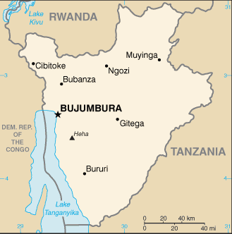
burundi with congo democratic & rwanda
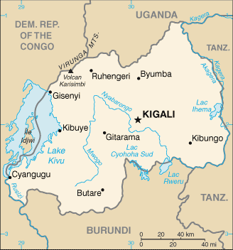
058 bicdrw tricountry point since independence of burundi & rwanda in 1962 succeeding belgian colonial administrative trijunction that emerged from 1916 conquest of german east africa in a location already loosely tripartite as of 1910 bede boundary adjustment finally fixed by 1949 belgian colonial delimitation at confluence of the luhwa & rusizi rivers presumably at thalweg junction per ibs in roughly s2d44m40s2 e29d2m25s8 wgs84 per best known mapping where it is frequented by a monstrous crocodile named gustave
ibs 48 52 72
burundi with congo democratic & tanzania
059 bicdtz tricountry conjunction since independence of belgian congo in 1960 reaching present form in 1964 after several additional political changes succeeding binational colonial trijunction created in 1924 where begb partition of german east africa mandate met 1910 bede boundary on indefinite median line of lake tanganyika due west of begb pillar number 1 at mouth of ndyakalika ravine & thus situated in roughly s4d26m30s & very loosely 29e25
ibs 48 51 70
burundi rwanda tanzania
060 birwtz tricountry point since simultaneous independence of burundi & rwanda in 1962 succeeding intercolonial administrative trijunction established by 1924 if not 1919 begb partition of german east africa which upgraded a loosely defined internal administrative tripoint dating perhaps from 1885 if not indeed a precolonial triple frontier as well evidently fixed by belgian ordinance of 1949 at thalweg junction of mwibu & kagera rivers in roughly s2d24m44s e30d32m30s wgs84 tho the mwibu & its thalweg are so negligible that they have not been mentioned since 1934 & the kagera is evidently quite changeable thus leaving the exact tripoint location in some doubt
ibs 69 70 72
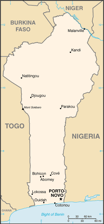
benin niger nigeria
061 bjneng tricountry point since independence of dahomey aka benin in 1960 very briefly as bjfrgb & bjnegb til independence of nigeria also in 1960 at a location established & fixed by 1898 & 1906 frgb agreements that made it a binational colonial tripoint but displaced slightly in 2005 by icj bjne judgment from median line of niger river to thalweg at point 154 in n11d42m39s e3d35m18s clarke1880ellipsoid
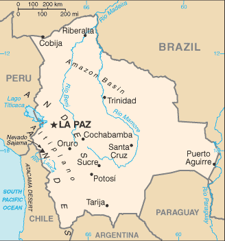
bolivia brazil peru
062 bobrpe while maps have shown a trijunction of these countries at many & various locations & times since their independence in the 1820s the present tripoint position at the median junction of the rivers yaverija & acre in roughly s10d56m45s w69d34m20s which was first negotiated evidently in 1899 did not finally become effective until 1909 upon rectification of an arbitral award made earlier that year pursuant to 1902 bopy & 1903 bobr accords
bolivia brazil paraguay
063 bobrpy while maps have shown a trijunction of these countries at or near the present location since the early 19th century the tripoint was finally fixed if not simply reaffirmed by 1938 bopy arbitral award effectively culminating gran chaco war precisely at thalweg junction of rio negro with rio paraguay insofar as 1867 bobr & 1927 brpy delimitations had likewise followed thalwegs of their respective river sectors
ibs 165
bolivia chile peru
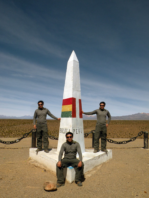
064 boclpe original tricountry point established in 1929 by treaty of lima finally settling war of pacific half a century afterwards & giving rise to tripartite obeliskoid monument aka clpe marker 80 at visviri incorporating 1906 bocl marker 5 which had been erected at point 94 of the bocl peace treaty delimitation of 1904 but was evidently chosen by the 1929 demarcators for its location 10km north of the arica la paz railway in conformity with the clpe treaty & which thus transformed into bope all the prior bocl sector northward of the tripoint in roughly s17d29m54s w69d28m6s wgs84 per aerial photo
brazil colombia peru
065 brcope tricountry conjunction established implicitly by 1928 brco treaty on thalweg of amazon in conformity with explicit 1922 cope agreement but also indefinite 1851 brpe delimitation evidently set due west of rather than perpendicular to mouth of san antonio creek which separates leticia & tabatinga & thus in very roughly s4d13m30s w69d56m55s
ibs 174

brazil colombia venezuela
066 brcove long contested tricountry conjunction effectively settled around 1900 judging from period maps by completion of slightly irrational triple intersection of 2 geodesic boundary lines & the thalweg of the rio negro supposedly somewhere between the rock of cocuy situated on east bank & san jose island situated near west bank but terminal beacon pairs erected in 1930 & 1935 respectively to renew & project original brve alignment dating from 1859 & to establish & project brco alignment pursuant to 1907 accord appear to cause these boundary segments to meet on west bank of river near south end of island rather than within river channel due east of island as might have been expected & thus constructed & situated a bit imperfectly at around 1n14 66w51
ibs 174 175
brazil france suriname
067 brfrsr triple frontier of separation in unknown amazon & maroni watersheds more or less continuously since 1667 treaty of breda initially as frnlpt til succeeded by brfrnl in 1822 on independence of brazil & not reaching present political form til independence of suriname in 1975 but sharply narrowed by frnl accord of 1836 to source of maroni river albeit then still geographically unknown & narrowed further by frnl arbitral award of 1891 to source of lawa affluent specifically tho it too was then still unknown beyond rough longitude on remote & possibly still nameless ridge until delimitations in brfr arbitral award of 1900 & brnl agreement of 1906 converged from east & west along this ridge which had by then been identified as tumucumaque & ultimately led a 1938 brnl commission to emplace upon it an unnumbered if not unacknowledged & unconfirmed tripoint mark at source of coule coule headstream of litani affluent of the lawa in roughly 2n20 54w36 where it was revisited in like manner by 1962 brfr commission & now also appears to have been surmounted by a french tower tho the location has remained disputed by nl & later by sr as well in whose view the trijunction should rather lie some 20 miles southeastward at the source of a different affluent of the lawa maroni named in fact marowini or marouini tho clearly not the same as the greater maroni aka morowijne in view of the intervening contributary name of lawa & decades if not centuries of french effectivity & enforcement in the disputed area
brazil guyana suriname
068 brgysr triple frontier of separation in remote amazon & courantyne watersheds intermittently since 1667 treaty of breda & continuously since 1815 treaty of paris first as gbnlpt but succeeded by brgbnl in 1822 & brgynl in 1966 before reaching present composition in 1975 reduced by exploration in 1842 to presumptive trijunction at source of kutari headstream of kuruni affluent of courantyne but compromised by discovery in 1871 of possibly greater western fork named new river which was soon claimed by nl yet was ignored by brnl & brgb delimitations & demarcations between 1906 & 1940 that ultimately designated a putative tripoint position at 1938 brgb pillar 132 of masonry on large rock outcrop of elev463m named farogle by its discoverers farabee & ogilvie in 1913 & situated in gap between tumucumaque & acarai ridges at roughly 1n58 56w27 tho this location was not finally agreed by nl & has remained disputed by sr which insists on source of new river in about 1n27 58w26 regardless of continuous british & later guyanese effectivity & enforcement
brazil guyana venezuela
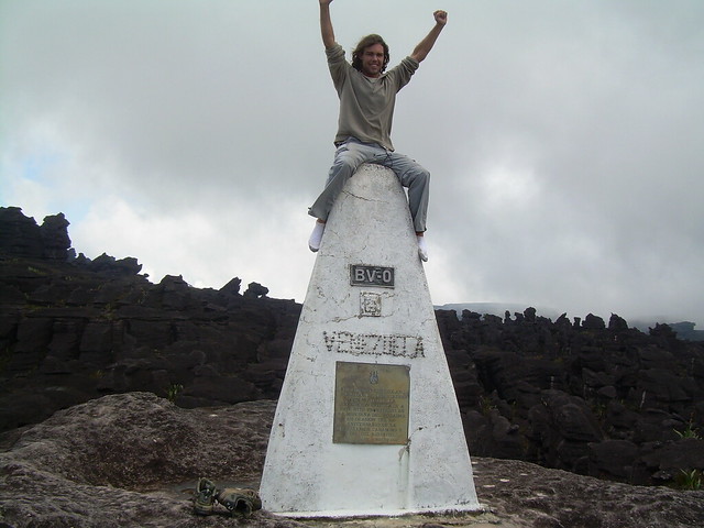
069 brgyve triple frontier of separation encompassing unknown areas of amazon orinoco & essequibo basins since perhaps early 17th century tho not clearly mapped as such til mid 18th while emerging first as esnlpt & alternating as esgbpt between 1666 & 1814 & succeeded by bresgb in 1822 & brgbve in 1830 on way to present format in 1966 even as the putative trijunction now commonly known as the triple point was itself emerging since mid 19th century upon the multiple watershed divide of the local headstreams now called respectively cotingo arabopo & paikwa near the summit of mount roraima at elev 2772m in roughly 5n12 60w44 where it was finally marked in 1931 trilaterally by a pyramoid monument numbered bv0 pursuant to 1926 & 1859 brve agreements & likewise in confirmation of 1926 rectification of 1904 brgb arbitral award & afterwards also confirmed by 1932 gbve accord completing demarcation begun in 1902 pursuant to 1899 arbitral award yet was repudiated in 1949 by venezuela owing to belated allegations of an arbitral impropriety committed half a centtury earlier & has remained in dispute by venezuela which would place the tripoint rather at the source of the essequibo around 1n15 58w55 notwithstanding more than a century of british & later guyanese effectivity & enforcement
ibs 21 175
bhutan china india east
070 btcnine triple frontier of separation of various historic states in remote himalayas since time immemorial as btcngb from 19th if not 18th century til reaching present format in 1947 on independence of india believed to be undelimited in any way but sharply narrowed positionally by 1962 cnin war to de facto trijunction atop thagla ridge just southeast of me la pass at traditional limits of bhutan & western end of so called line of actual control or roughly 27n52 91e37 in an area reportedly not covered by unpublished btin accords of 2006 & moreover unresolved by btcn discussions thru 2010 a few miles north of position shown at bhutan end of mcmahon line on most conventional maps but rejected in any case by china which claims adjacent tawang district if not all of arunachal pradesh state of india & an unspecified trijunction position much farther south regardless of centuries of british & later indian effectivity & control
bhutan china india west
071 btcninw triple frontier of separation of various states intermittently for many centuries in remote himalayas as btcngb from 19th century til emerging in present form perhaps in 1947 upon indian independence if not actually in 1975 upon formal union of sikkim with india first assigned rather indefinitely to mount gipmochi aka gyemo chen by 1890 cngb delimitation but an otherwise definite albeit unpublished 2006 btin delimitation has also left the trijunction unresolved as have btcn discussions thru 2010 while china has occupied up to 89 sq km of the doklam plateau southeast of strategic nathu la pass & has announced plans to extend a railway to yadong 10 miles from contested area by 2017
botswana namibia south africa
072 bwnaza original tricountry point created by independence of namibia in 1990 ultimately inheriting degb tricolonial point established in 1895 at roughly 24s45 20e0 in the normally dry bed of the nossob river is shown on some maps as being demarcated on the spot tho no marker has yet been reported by visitors so the position could well be unmarked or the marker could be washed out but more likely it is just obscured by the continuous bwna & naza fence line & possibly also situated farther north than visitors normally coming from the south & prohibited from continuing beyond the end of the road have yet realized so perhaps about s24d44m50s
botswana namibia zambia
073 bwnazm at the ill defined convergence of 4 countries in the confluence of the chobe & zambezi rivers at roughly s17d47m35s e25d15m50s the de facto botswana zambia frontier with ferry service is more noticed & active than its namibia zimbabwe counterpart alternative so a bwnazm trijunction is commonly presumed to lie directly above the ferry crossing just as a bwzmzw trijunction is similarly presumed to lie directly below the crossing
ibs 123

botswana namibia zimbabwe
000 bwnazw tho it flies in the face of both common perception & governmental assertion nevertheless the existence of a bwnazw trijunction produced by conflicting de jure boundaries & the resulting territorial overlap not only cannot be ruled out but actually is shown by best available mapping at a location near the right bank ferry slip in very roughly s17d47m35s e25d15m50s & is thus included in the registry tho not enumerated or counted in the inventory pending further clarifications particularly of the precise locations of 1907 & 1959 bwzw terminal beacons numbered 226 & 842 respectively at & near the right bank of the zambezi & also of the possibly equally definitive but still unpublished report of a 2003 bwna redelimitation & demarcation commission
see also bwnazm above & bwzmzw below & 000 nazmzw far below
ibs 148
botswana south africa zimbabwe
074 bwzazw officially a tricountry conjunction since independence of botswana in 1966 inheriting british colonial trijunction dating from 1898 most probably at the median junction in the confluence of the shashi & limpopo rivers in roughly s22d11m41s e29d22m37s tho only the zazw convergent ascending the lower limpopo is precisely delimited on the midline
but all 3 maps show a distinctly different tripoint position & both rivers often run dry & thus project downstream or even suspend their median junction from time to time
ibs 117 122 148
botswana zambia zimbabwe
075 bwzmzw the situation in this case is essentially identical as well as geographically very close to that of the bwnazm trijunction listed & described above except bwzmzw is generally presumed to lie directly below the ferry crossing also in very roughly s17d47m35s e25d15m50s
however boundary clarifications expected for a planned bridge construction project make it likely that more definitive data including the still unpublished results of a 2003 bwna demarcation will soon become available & that the purported bwzmzw & bwnazm trijunctions will become entirely supplanted in common perception & in the tricountry registry by the technically already more probable bwnazw & nazmzw trijunctions
all which see also above & below
ibs 30 148
belarus latvia lithuania
076 byltlv tricountry point since independence of latvia in 1990 initially as ltlvsu til independence of belarus in 1991 inheriting soviet tristate point dating probably from creation of latvian & lithuanian ssrs in 1940 comprising concrete demarcations in 6 meter neutral square near liudevinova lake in n55d40m50s46h e26d37m49s39h wgs84 per aerial photo
belarus lithuania poland
077 byltpl former tricountry conjunction as deltsu from 1939 to 1940 revived by lithuanian independence in 1990 as ltplsu til independence of belarus in 1991 inheriting binational trijunction that emerged from molotov ribbentrop pact when lithuania was finally absorbed by soviet union rather than germany in 1940 & which was reconfigured to its present trifinial arrangement by transfer of bialystok region from soviet union to poland in 1946 & is situated in roughly n53d57m22s e23d30m54s on median line of mara aka maricha aka marycha river beside a now solitary lithuanian witness marker 1789 since the former plsu marker pair of the same number dating from 1947 have recently been removed while a comprehensive trilateral agreement was completed in 2011
belarus latvia russia
078 bylvru tricountry point since independence of belarus in 1991 first briefly as bylvsu inheriting soviet tristate conjunction dating from 1940 & now situated at intersection of center lines of neverica aka neveritsa & zilupe aka sinjuha or sinyukha rivers in roughly n56d10m11s e28d9m0s wgs84 after being displaced by agreement about 100 meters ssw from actual soviet position on ceremonial friendship mound or kurgan druzhby purportedly dating from 1950s & today fully on latvian soil
belarus poland ukraine
079 byplua tricountry conjunction since breakup of soviet union in 1991 succeeding binational trijunction created in 1939 when germany & the soviet union first agreed to the curzon line originally proposed in 1919 & restored in 1946 by poland & the soviet union & today situated following if not pursuant to trilateral agreement drafted in 1998 apparently at triple intersection of median line of western bug river & prolongation of south bank of moscickogo canal & sight line between plsu riparian marker pair numbered 1123 in roughly n51d30m30s e23d37m4s wgs84 per aerial photo
belarus russia ukraine
080 byruua presumptive tricountry point restored possibly at original location by collapse of soviet union in 1991 succeeding internal tristate conjunction created in 1922 at birth of soviet union pursuant to prior byruua tricountry convergency dating from 1919 or earlier & now apparently centered on pedestal plaza of towering kurgan druzhby monument erected in 1975 as wwii memorial in roughly n52d6m42s e31d46m53s wgs84 yet actually unmarked & indeed generally ignored because the monument as a whole is so overwhelming
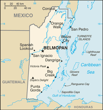
belize guatemala honduras
081 bzgthn notional tricountry conjunction of indefinite territorial seas since breakup of federation of central america in 1843 albeit as gbgthn til independence of belize in 1981 situated however vaguely in gulf of honduras perhaps since gbgt treaty of 1859 & much less vaguely since gthn award of 1933 & moreover partly negotiated in 2002 yet still only a hypothetical equidistant tripoint today at roughly n15d55m12s w88d10m48s per vliz
ibs 8 157
belize guatemala mexico
082 bzgtmx notional tricountry point reaching present form in 1981 on independence of belize established as gbgtmx by 1893 gbmx agreement pursuant to 1882 gtmx & 1859 gbgt accords & first demarcated tho only bilaterally & a bit imperfectly by 1899 gtmx terminal monument number 107 named vertice aguas turbias which stands in roughly n17d48m56s w89d9m7s wgs84 at intersecting gtmx & bzmx sight lines today but corrected & redemarcated by 2002 bzgt commission albeit still only provisionally at a position some 200m due east of first marker & thus at roughly w89d9m0s wgs84 where it was accepted by mx yet has still not been finally agreed by bz & gt
because the later more easterly position as indicated on this zoomable satpic map http://maps.google.com/maps?hl=en&tab=wl&q=17.81556%2C%20-89.15 involved a concession of historical error & appeared fully agreeable it seems likely to become formally adopted but the bzgt dispute as a whole was last reported on its way to the icj in 2008 subject to parliamentary & popular approvals before drifting into obscurity again as ever
ibs 8 159 161
cambodia kh
central african republic with congo democratic kinshasa & congo brazzaville
083 cdcfcg tricountry conjunction since independence of car in 1960 first briefly as cdcffr succeeding binational colonial trijunction nominally situated on thalweg of ubangi river pursuant to befr agreements of 1894 & 1887 at confluence of gouga per french subdivisional boundary adjustment of 1942 in roughly 3n29 18e38 where it lies hypothetically opposite the center of the mouth of the gouga since the cfcg delimitation within that stream is indefinite
moreover because the ubangi thalweg is variable & not readily identifiable the following downloadable topo http://en.poehali.org/maps/200k--a34-01.html sensibly shows many islands in the ubangi including a tripoint island named ile longue as being divided rather than allocated
ibs 109 127 145
central african republic with congo democratic & south sudan
084 cdcfss multicountry point at nile & bomu watershed divides emerging from triple frontier of separation circa 1890 but fully agreed by 1899 first as befrgb & on independence of egypt in 1922 as beegfrgb quadricountry trijunction til becoming simply befrsd in 1956 upon independence of sudan & briefly cdfrsd on way to cdcfsd in 1960 & present form in 2011 marked in 1924 by monumental rock heap attested by colonial agreements to be located at n5d1m10s e27d26m37s in an unknown datum & actually at n5d1m13s55h e27d27m12s50h wgs84 per aerial photo
ibs 16 106 109
congo democratic with rwanda & uganda
085 cdrwug triple frontier of separation from perhaps 1885 variously allocated during 1890s & 1900s & ultimately winnowed by 1910 bedegb accord to tricountry point at summit of mount sabinyo elev3634m in roughly s1d23m16s e29d35m30s where it was confirmed with bilateral delimitations completed in 1915 only to be reduced to a binational tricolonial point by anglo belgian invasion of german east africa in 1916 & ensuing redistributions until restored to tricountry status in 1960 as becdgb on independence of congo before transitioning in 1962 thru cdgbrw to present form on successive independences of rwanda & uganda but probably still unmonumented because numerous peak baggers have not reported seeing any markers in the mist
ibs 52 54 108
congo democratic with south sudan & uganda
086 cdssug historically intermittent notional tricountry conjunction first as befrgb from perhaps 1894 to 1898 when reduced to begb binational administrative trijunction by french withdrawal from sudan but not identified with present location on nile congo watershed divide in roughly 3n29 30e52 until begb & british delimitations of 1913 & following tricountry resurrection to beeggb in 1922 upon independence of egypt & devolution to begbsd in 1956 on independence of sudan & to cdgbsd in 1960 on independence of congo & cdsdug in 1962 on independence of uganda on its way to present form in 2011 on independence of south sudan still not yet fixed with certainty today tho described in uganda constitution as a point about 300 meters south of the source of the river kaia
ibs 104 106 108
congo democratic with tanzania & zambia
087 cdtzzm intermittent tricountry area revived by independence of tanganyika in 1961 & reconfigured by zanzibar union in 1963 as cdgbtz til 1964 independence of zambia in direct succession to original bedegb triple frontier dating from late 1880s acknowledged by 1890 degb & 1894 begb accords before being reduced to binational tricolonial status by german losses of 1919 & today generally considered to lie on median line of lake tanganyika in roughly 8s12 30e46 at a precise position reportedly stipulated in unpublished if not also unratified 1989 cdzm accord but in any case aligned since 1894 with a certain lost cape akalunga possibly now called pungu of southern lake tanganyika on one side & on the other an uncertain point on north shore of lake mweru near pweto village & luvua river outlet
ibs 44 51
cameroun with central african republic & congo
088 cfcgcm indefinite tricountry convergence since independence of all parties in 1960 succeeding french colonial administrative trijunction dating probably from 1926 complicated by anomalous island allocation but presumably situated just below village of nyangoute car near tricountry game control hq per recent reports on lesser thalweg or if that is indiscernible then on lesser median of sangha river in roughly n2d12m59s e16d11m38s wgs84 based only on inconsistent map evidence in absence of cfcg demarcation
ibs 107 110 145
cameroun central african republic chad
089 cfcmtd indefinite tricountry conjunction since independence of all parties in 1960 succeeding french administrative trijunction as adjusted in 1942 from prior location on the upper mayo senabou dating from 1914 based even today only on colonial map evidence & nominally or roughly located at n7d31m40s e15d29m40s per ibs but in any case situated on thalweg if discernible or else on median line of mbere river pursuant to 1908 defr protocol & likely coincident by chance or design with minor stream entering from opposite bank at sharp bend of river
ibs 83 102 107
central african republic with sudan & south sudan
090 cfsdss westerly trijunction of south sudan with rump sudan created in july 2011 in tandem with etsdss below at original 1956 interregional position per 2005 peace treaty & 2011 referendum but gaps in historical map evidence leave location in doubt between earlier position at jebel mishmir in roughly 9n40 23e42 & later position as revised by northward transfer of kafia kingi district in 1960s on northeast shoulder of jebel aburasein in roughly 8n38 24e15 while present political & military realities seem to favor the latter probability
central african republic chad sudan
091 cfsdtd indefinite tricountry conjunction initially as frsdtd since independence of chad in 1960 til reaching present form soon afterwards succeeding tricolonial administrative trijunction established evidently during the 1920s tho possibly not actually formalized til 1942 on median line more likely than thalweg of westward flowing headstream of the aoukale river apparently named toror exactly 1km east pursuant to 1924 frgb agreement tho actually east southeast of the easternmost point of lake tizi & thus in roughly 10n56 22e52 where it is believed to remain undemarcated
ibs 15 16 83
cameroun congo gabon
092 cgcmga tricountry conjunction since independence of all parties in 1960 succeeding french & previously franco german administrative trijunction dating from 1910 probably fixed on thalweg of river ayina if discernible but otherwise on its median line at the designated intersection of n2d10m20s per 1908 defr accord inherited by cgcm & cmga tho the slightly later cgga convergent may not have been so carefully delimited & thus in roughly 13e18 but also placed explicitly by the ibs near marker 13 which tho unexplained is likely the original defr riparian witness mark & geodesic terminal pillar circa 1908
ibs 110 115
chad td
france germany switzerland
093 chdefr tricountry point on thalweg most likely of rhine since 1814 treaty of paris placed defr component thereon & where ibru today places chfr component also if without explanation in alignment with a pair of 1818 terminal markers which project chde geodesic component into river from the right bank
ibs 11
france italy switzerland
094 chfrit present tricountry point established by 1815 congress of vienna succeeding various earlier frontiers & administrative divides at probably still unmarked ridge junction in elev3750m at roughly n45d55m22s e7d2m40s wgs84 about 70m below & 160m northwest of summit of mont dolent where it generally goes unnoticed by passing peak baggers as there are no known reports of deliberate tripoint visitation but for common misapprehension of summit as boundary conjunction
ibs 4 11 12
cote d ivoire with guinea & liberia
095 cignlr tricountry point since independence of guinea in 1958 initially as frgnlr til independence of cote d ivoire in 1960 succeeding binational tripoint established by french administrative division in 1893 following original 1892 frlr accord but evidently revised slightly in 1911 to northwesternmost source of nuon river on crest of nimba mountains in roughly n7d33m26s w8d28m14s wgs84 where it is reportedly marked by a concrete post which may be a 1929 frlr pillar
ibs 131 132
cote d ivoire with guinea & mali
096 cignml indefinite tricountry conjunction since independence of cote d ivoire in 1960 first briefly as cifrgn til independence of mali later in the year succeeding uncertain french colonial trijunction position dating evidently from 1899 administrative reorganization supposedly situated at source or headwaters of dougoulinfolo on baoule sankarani drainage divide in roughly n10d10m15s w7d58m40s per ibs but the trifinium appears on all known maps merely among the headwaters generally & within a few miles of the divide
ibs 171
cameroun with equatorial guinea & gabon
097 cmgagq indefinite former & present tricountry convergence originally as deesfr triple frontier from 1885 til delimitation as tripoint in 1908 & discontinuance in 1911 due to enlargement of kamerun restored to tricountry status on independence of cameroun in 1960 first as cmesfr before becoming cmesga later that year on way to present form in 1968 succeeding binational administrative trijunction established circa1925 at northeast corner of rio muni just south of kye ossi cm & just north of ebebiyin gq in very roughly n2d10m20s 11e20 where it is joined pursuant to the colonial delimitation by an indefinite segment of cmga projected from the confluence of the rivers kye & mvenou aka mvezeu lying some 3km to the east southeast but notwithstanding & nevertheless there are many clear indications including a 1974 presidential acknowledgment & subsequent maps that equatorial guinea has gained de facto a slight bulge extending eastward from ebebiyin to the kye as far north as the abovementioned confluence thus effectively displacing the trijunction eastward to the confluence area & diffusing it again into a triple frontier at around 11e22 in that case
ibs 115
cameroun chad nigeria
098 cmngtd former & present tricountry conjunction dating from 1891 as defrgb triple frontier of separation eventually winnowed per 1906 frgb & 1908 defr accords to notional tripoint & situated roughly as at present on then still lacustrine but now dry matted bed of southern lake chad before being reduced by german departure in 1916 to a binational administrative trijunction yet revived reconfigured & refined as a tricountry point in 1960 by decolonization of all its by then slightly altered parts after being redelimited in the interim as well as definitely fixed by 1931 frgb agreement at 13n5 14e5 albeit without regard to datum
ibs 90 92 102
china india myanmar
099 cninmm ancient multiple frontier of separation in remote eastern himalayas emerging as distinct tricountry conjunction since independence of india in 1947 as cngbin til burma independence in 1948 situated de facto at or near east end of historic mcmahon line & present line of actual control at ridge junction where irrawaddy & two brahmaputra watersheds divide just above & north of diphu la pass but while the position also fits in with 1960 cnmm & 1967 inmm delimitations disputed by china nevertheless which claims arunachal pradesh state of india in its entirety & thus a trijunction position hundreds of km to the southwest however unrealistically
ibs 42 80
china india nepal east
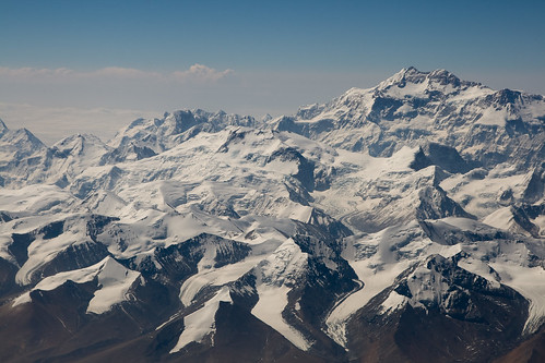
100 cninnpe ancient triple frontier of separation in remotest himalayas sharply narrowed while still cngbnp by 1817 gbnp & 1890 cngb accords & after reaching present form upon independence of india in 1947 by 1960 cnnp accord as well which affixed it to the probably still unmarked summit point of jongsang peak in roughly 27n53 88e8 at elev7463m where it serves as the highest tricountry point in the world as well as the most agreeable of the 6 cnin trijunctions
ibs 50
china india nepal west
101 cninnpw ancient multiple frontier of separation in remote himalayas substantially reduced by 1816 gbnp accord & after reaching present composition on independence of india in 1947 narrowed further by 1960 cnnp agreement to watershed divide between mapchu & kali river & its tinkar tributary but in the absence of any cnin agreement westward of nepal & in the presence of longstanding confusion about river names & true headstreams the location of the tricountry point is still subject to differing interpretations while an unmarked ridge junction directly above & south of lipu lekh pass in roughly 30n12 81e02 has been maintained de facto by india since 1962 & informally acknowledged by china tho rejected by nepal which claims an additional triangular territory bounded by the kiti aka mahakali or greater kali river & extending as far west as limpiyadhura pass in roughly 30n28 80e35
ibs 50
china india pakistan
102 cninpk tho karakoram pass has been provisionally agreed by china & pakistan in 1963 & is often misconstrued as de facto triple frontier arising from partition of india in 1947 nevertheless the actual limit of indian control on the karakoram ridge beyond the cease fire line & stipulated loc of 1972 is today per indian intelligence some 100km northwest at or near sia kangri peak just above & west of indira col & siachen glacier
ibs 17 86
china kazakhstan kyrgyzstan
103 cnkgkz tricountry point since independence of kyrgyzstan in 1991 succeeding binational tripoint created in 1936 when administrative partition of soviet union attached it to a ridge junction & secondary peak of khan tengri evidently called shater at elev6637m in roughly 42n13 80e15 where it is probably still unmarked today some 5km east of primary summit point which rises several hundred meters higher
china kyrgyzstan tajikistan
104 cnkgtj tricountry point since independence of kyrgyzstan in 1991 succeeding binational tripoint created in 1924 when administrative partition of soviet union attached it to summit of zarya vostoka in elev6350m at roughly 39n28 73e39 where it was reportedly reaffirmed in 2000 & first visited then as well & is probably still unmarked today
ibs 64
china with north korea & russia
105 cnkpru tricountry conjunction in tumen river de facto from about 1860 when first partly agreed & marked but displaced in 1886 about 10km southeastward or downriver to present general location in roughly 42n25 130e38 where it was trilaterally acknowledged at least implicity by around 1888 & after being suspended by japanese conquests in both korea & china between 1905 & 1945 substantially shaped since 1985 by a series of bilateral & trilateral agreements & demarcations into the form of a condominial triline spanning the left half of the ambulant water space of the river between remote monuments some 400 meters above friendship bridge tho the exact location remains uncertain if not actively disputed because the river is so variable & the markers & documentation elusive
easternmost tricountry conjunction in the world
ibs 17 59 64
china kazakhstan russia
106 cnkzru tricountry point since kazakh independence in 1991 succeeding binational tripoint created in 1936 by soviet administrative partition at nameless probably unmarked ridge junction elev3424m in roughly 49n7 87e17
ibs 64
china laos myanmar
107 cnlamm ancient triple frontier of separation distilled to tricountry point in mid 1890s initially as cnfrgb & having reached its present political format in 1953 upon decolonizations slightly adjusted by tripartite agreement in 1994 to thalweg junction of mekong & nan la ho in roughly n21d33m49s e108d8m38s wgs84 where it is aligned at stipulated azimuths & distances with direct cnla pillar 45 on left bank & indirect cnmm pillar 245 on right bank
comparison of the above topos with recent aerial photography suggests the mouth of the tributary may actually have migrated southward toward the previously established tripoint location at the foot of the adjacent watershed divide & that the cnla boundary may thus not actually have been displaced at all northward to meet the nan la ho
ibs 33 34 42
china laos vietnam
108 cnlavn ancient triple frontier of separation overridden by french conquest in late 19th century & pursuant to 1895 cnfr accord & lavn agreements dating from 17th century or earlier finally reduced in 1930 by french colonial partition to a binational administrative tripoint at summit of shiceng dashan aka khouang lashan mountain elev1853m in roughly n22d24m1s e102d8m38s wgs84 where it was restored to tricountry status in 1945 by independence of vietnam & laos & received its first tripartite marker in 2005 but full agreement only in 2006
ibs 34 35 38
china mongolia russia east
109 cnmnrue tricountry conjunction traceable to mongolian declaration of independence in 1911 which was opposed by china until 1945 or 1960 & compromised during that period by the soviet union also likely assigned to present location albeit only as a binational tripoint by 1915 cnru delimitation of autonomous but still chinese suzerain outer mongolia & possibly first acknowledged as tricountry point in the form of jpmnsu by 1940 jpmn demarcation but not recognized by china until cnmn accord of 1962 & demarcation of 1964 tho present marker in roughly n49d50m44s2t e116d42m50s5t wgs84 erected in 1993 & elevated above salt marsh on stilts is first tripartite marker
ibs 64 173
china mongolia russia west
110 cnmnruw tricountry conjunction in development since mongolian declaration of independence in 1911 which was opposed by china until 1945 if not 1960 & compromised during that period by the soviet union as well probably first assigned to present location at nairamdal or friendship peak ridge junction & minor summit of tavanbogd massif in elev4082m at roughly 49n10 87e48 as a binational tripoint by 1915 cnru delimitation of autonomous but still chinese suzerain outer mongolia & after considerable disputation first acknowledged there as a tricountry point by cnmn accord of 1962 which was followed by a general demarcation but this remote tripoint is likely still unmarked today
ibs 64 173
colombia ecuador peru
111 coecpe multiple frontier of separation in remote upper amazon from early postcolonial times long subject to various conflicting claims & military actions & abortive resolutions yet reduced to an apparent territorial trijunction only since 1899 on conventional maps & tho conflict continued intermittently til 1998 actually settled & fixed in 1942 by rio protocol on thalweg of rio putumayo opposite center hypothetically of mouth of rio gueppi in roughly s0d6m50s w75d15m28s wgs84 where it is witnessed by 1999 ecpe reference marker 206 pursuant to original 1942 witness monument aka hito boca gueppi
ibs 172
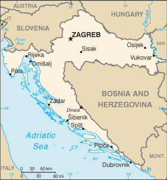
croatia hr
czech republic with germany & poland
112 czdepl tricountry point with present political composition since breakup of czechoslovakia in 1993 at present location in roughly n50d52m14s e14d49m24s wgs84 since 1945 potsdam conference moved it some 280km northwestward from original 1919 position along inherited hapsburg & earlier bohemian frontier where it is situated at median junction of lusatian neisse & obliquely convergent lubota aka oldrichovsky brook & thus perpendicularly opposite center of tributary mouth a geometrical relationship evidently overlooked by a projected monumental encirclement http://www.flickr.com/photos/54128956@N00/4133542047/sizes/l/in/pool-632069@N23/ which may therefore encourage eccentric amphibious visitation
czech republic with poland & slovakia
113 czplsk tricountry point since breakup of czechoslovakia in 1993 succeeding binational tripoint created by partition of teschen silesia in 1920 between poland & czech moravia first marked directly in 2007 by low obeliskoid pillar in mostly dry creek bed at roughly n49d31m2s e18d51m4s wgs84 precisely spaced between 3 much larger & quite remote but matching reference obeliskoids
france germany luxembourg
114 defrlu tricountry conjunction since creation of prusso dutch condominium in 1815 revised politically by independence of belgium from netherlands in 1830 & of luxembourg from belgium in 1839 as well as by unification of germany in 1871 having the form of a demarcated riverine condominial triline traversing the right or eastern half of the main channel of the moselle river & a lock island & side channel situated in very roughly n49d28m10s e6d22m5s wgs84 having been reaffirmed & clarified by 1984 delu agreement
djibouti eritrea ethiopia
115 djeret late 19th century triple frontier of separation in remote badlands initially as etfrit distilled to notional tripoint 60km from seacoast by 1908 etit accord pursuant to 1901 frit delimitation but reduced to binational status in 1935 by italian conquest of ethiopia til resurrected as etfrgb in 1941 by british seizure of eritrea & liberation of ethiopia til reduced again in 1952 by confederation of ethiopia with eritrea til resurrected again after djibouti independence in 1977 by independence of eritrea in 1993 when present political format was finally reached tho not before the location had become loosely assimilated with 1954 etfr pillar 90 on the summit of musa ali where virtual demarcation by eebc in 2007 finally fixed it as a definite tripoint at elev2021m in n12d28m7s1t e42d24m15s4t eebd2002 datum
djibouti eritrea yemen
116 djerye notional maritime tricountry conjunction depending on uncertain extent of territorial sea claims during various periods but possibly dating from 1901 frit land boundary delimitation & if so then initially as frittr but devolving repeatedly thru numerous liberations conquests & unions to present political format in 1993 & assuming equitable allocation of the dumeira islands long in dispute between djibouti & eritrea & now under qatari mediation a hypothetical equidistant tripoint in the bab al mandab at roughly 12n46 43e17 tho vliz indicates the position at approx n12d41m24s e43d16m12s for reasons unknown while the 1999 erye agreement ends at n12d54m23s e43d13m58s or well short of the disputable area
djibouti ethiopia somalia
117 djetso triple frontier of separation in remote badlands emerging as notional tripoint perhaps as early as 1888 per frgb accord whether as frgbit at first or etfrgb being debatable but precipitated by 1897 etgb & etfr agreements to a definite tricountry point atop madaha djalelo hill elev492m at roughly n10d59m50s e42d58m3s wgs84 in detached somaliland today where it was first marked by a 1934 etgb pillar with french concurrence & then reconstituted or restored as frgbit by italian reinvasion of ethiopia in 1935 & also briefly reduced from tricountry status by italian invasion of somaliland as well in 1940 til fully restored by british military action in 1941 & redemarcated by 1953 etfr primary monument number 1 before devolving to etfrso in 1960 upon somalian independences & confederation & reaching present nominal format upon djibouti independence in 1977
ibs 87 153 154
algeria libya niger
118 dzlyne tricountry conjunction however elusive since independence of niger in 1960 as frlyne til algerian independence in 1962 inheriting binational administrative trijunction created in the 1920s by french mapping at an uncertain point of the 1919 frit boundary on the ridge of garet derouel el djemel & tho identified in the 1950s also by french mapping as an astronomical point of elevation 1010m upon that ridge which was determined & reported per ibs at n23d30m54s e11d59m54s6t nevertheless after decades of doubt & confusion placed squarely at 23n30 e12 by 1985 & later soviet topos likely for good reason
ibs 1 2 99
algeria libya tunisia
119 dzlytn tricountry conjunction since independence of tunisia in 1956 as frlytn til independence of algeria in 1962 succeeding frit & earlier frtr binational administrative trijunction shown on maps since 1841 in various locations & first actually fixed in 1911 pursuant to frtr delimitations of 1886 & 1910 at 1911 frtr pillar 220 per french executive decision however compromised after 1923 by inconsistent french military mapping but following other occupations & liberations displaced a few hundred meters westward & demarcated anew there by 1970 dztn pillar 1 at roughly n30d13m45s e9d33m34s wgs84 judging from aerial photo
ibs 1 121
algeria mauritania morocco
120 dzmamr uncertain tricountry conjunction since independence of mauritania in 1960 as frmamr til independence of algeria in 1962 succeeding binational administrative trijunction established in principle by french executive decision in 1911 pursuant to 1905 military decision & 1904 esfr accord & tho probably unmarked said to be situated on north bank of a wadi in 8w40 & at n27d17m40s per ibs while subsequent soviet mapping repeatedly shows the position in roughly n27d21m45s & far from any wadi
ibs 84 88 149
algeria mali mauritania
121 dzmlmr unmarked rather indefinite tricountry conjunction since independence of mauritania in 1960 as frmlmr til independence of algeria in 1962 succeeding french colonial administrative trijunction in present approximate location since 1944 where oblique southern boundary of algeria dating from 1905 crosses n25 as reaffirmed by 1963 mlmr agreement & thus at 4w50 per ibs & brownlie but shown by later soviet mapping at about w4d48m40s & by later malian mapping at about w4d49m50s
ibs 23 88 96
algeria mali niger
122 dzmlne uncertain tricountry conjunction since independence of mali in 1960 as frmlne til independence of algeria in 1962 succeeding french colonial administrative trijunction dating from 1909 at a position on the tamesna plateau said by french authorities in 1944 to be situated in 19n12 4e16 & still not fixed with certainty today but placed by the ibs at n19d8m30s e4d14m30s citing ign mapping & shown by later soviet mapping at more nearly 19n8 4e15
ibs 96 99 150
estonia latvia russia
123 eelvru historical tricountry point restored since independence of estonia in 1991 inheriting soviet republican tripoint devolved in 1945 from original eelvru tricountry conjunction which first arose with latvian independence in 1920 & survived til world war ii on median line of pededze river about 90 meters above laikupe confluence whither it was apparently displaced from confluence in late 20th century in roughly n57d31m6s e27d21m5s wgs84 where it is witnessed from the west bank by eelv marker number 46plus1379 aligned with lvru convergent entering river quite obliquely on a bearing of about n40e
egypt israel jordan
124 egiljo tricountry conjunction in gulf of aqaba since independence of jordan in 1946 initially as eggbjo til independence of israel in 1948 distilled to hypothetical equidistant maritime tripoint in 1996 at iljo terminal point mb3 which is recorded as n29d27m12s1667 e34d55m16s3595 in a specially created datum tho the location is still subject to egyptian concurrence
ibs 46
egypt jordan saudi arabia
125 egjosa tricountry conjunction in gulf of aqaba since independence of egypt in 1922 initially as eggbsa til independence of jordan in 1946 still only a hypothetical equidistant tripoint at roughly 29n23 34e52 per jordanian mapping
ibs 60
egypt libya sudan
126 eglysd tricountry conjunction at present general location since 1925 egit accord pursuant to 1899 eggb agreement but reconfigured in 1934 by transfer of adjacent sarra triangle from sudan to libya per eggbit agreement which also trilaterally confirmed tripoint location at precisely n22 e25 albeit in no particular datum & having devolved to eggbly on independence of libya in 1951 & to present form on independence of sudan in 1956 apparently still unmarked at still slightly indefinite location on steep nw shoulder of mt uweinat in elev roughly 800m
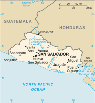
el salvador sv
equatorial guinea gq
eritrea ethiopia sudan
127 eretsd triple frontier of increasing contact from 1890 initially as etitsd but as etgbit after 1898 & as egetgbit quadricountry trijunction after independence of egypt in 1922 first demarcated as tripoint by iron post erected on north bank of river setit at sharp bend opposite mouth of khor royan by 1903 gbit commission in roughly n14d15m28s e36d33m37s wgs84 & after various devolutions by reduction & liberation beginning with italian invasion of ethiopia in 1935 & including the loss of quadricountry status upon sudan independence in 1956 & emergence in present form upon eritrean independence in 1993 essentially reaffirmed at the original location by the eebc virtual demarcation of 2007 tho the original marker was reportedly not recovered by the commission
slightly mistaken topo http://bit.ly/6HfU1h tho perhaps the most accurate available while the eebc virtual demarcation map remains unpublished
ethiopia kenya somalia
128 etkeso tricountry point since jubaland cession from britain to italy in 1925 tho geographically impossible conception delayed actual positioning til 1927 initially as etgbit & after suspension in 1935 by italian occupation of ethiopia restored as etgbit in 1941 til somalian independence in 1960 reformed it briefly as etgbso on way to present form upon kenyan independence in 1963 all while situated on thalweg of dawa river pursuant to 1907 etgb accord & by later descriptions about 450 meters above landing & ford at malca rie somalia & 650 meters nw of 1925 police post on mandera dolo road & thus in roughly n3d58m57s e41d54m24s wgs84 as projected by demarcation bearing of about n35e from 1930 gbit primary beacon 1 which is believed to be standing on right bank at end of old cut lane still visible in aerial photo
ibs 134 152 153

ethiopia & kenya with south sudan
129 etkess elusive tricountry conjunction since egyptian independence in 1922 as egetgb til italian occupation of ethiopia made it egitgb from 1935 to 1941 but then restored as egetgb til sudan independence in 1956 changed it to etgbsd & kenyan independence in 1963 brought it to etkesd en route to its present format in 2011 upon south sudan independence while its location too was slightly yet indefinitely adjusted by successive etke modifications of 1970 & 1963 upon equally indefinite 1947 & 1907 etgb agreements & tho an official position has still not yet been fixed with certainty nevertheless the trijunction de jure is probably at or near 1970 etke pillar d23 on relict shoreline of former sanderson gulf of lake turkana aka rudolf & reportedly near a water tower & about 200 meters south of the southeast end of an unconfirmed feature possibly of low sand hills named okolon ridge & arguably in very roughly n4d37m45s e35d57m5s while the de facto position may be as stated in 2002 kenya draft constitution at 5n25 & 35e18 or about 10km ssw of mount naita by most extreme reckoning but apparently in the absence of regular patrols
ibs 152
ethiopia & sudan with south sudan
130 etsdss easterly trijunction of south sudan with rump sudan created by south sudan independence in tandem with cfsdss above in july 2011 subject to confirmation by local popular consultation per 2005 peace treaty but due to later military activity now evidently situated de facto at or near 9n30 34e5
finland norway russia
131 finoru tricountry point originally in the form of finosu since moscow armistice of 1944 returned petsamo district from finland to the soviet union with trifinial configuration altered in 1947 by additional transfer of adjacent rayakoski parcel but fully normalized between 1945 & 1953 by various trilateral protocols elevating binational administrative tripoint of finnish norwegian & russian sami communes first marked in 1846 when norway was in sweden & finland was in russia by a cairn likely a russian finland archangel marker numbered 94 that is maintained in the present demarcation atop krokfjellet aka muotkavaara hill at elev145m in roughly n69d3m6s5 e28d55m44s5 wgs84 where it reached present political form on fall of soviet union in 1991 before being capped by tripartite pyramid whose apex few have dared to reach
ibs 24 74

finland norway sweden
132 finose historically intermittent & geographically shifty tricountry conjunction winnowed from 18th century multiple frontier of contact in 1809 as dkruse when first approximately fixed at present location very near variable & marshy southeast shore of lake goldajarvi at the intersection of its eastward thalweg with the sight line between primary cairns 293 & 294 of original 1751 nose alignment as demarked in 1760 but summarily reduced to binational trijunction ruse2finose by 1814 cession of norway to sweden by denmark & only after exact geographical determination & initial demarcation in 1897 by noru cairn with concurrence by sweden in 1901 resurrected no less abruptly to tricountry status by independence of norway from sweden in 1905 albeit as noruse til independence of finland from russia in 1917 & then redemarcated if not simply mortared over in 1926 on its way to becoming the focal point of an artificial sometime island surrounded by boardwalk access & promenade at elev495m in roughly n69d3m35s e20d33m10s wgs84 atop a rather portly & rotund but tapered concrete pedestal & protruding crown or core marker all together suggestive of a compact yellow submarine in a dock while actually the northernmost tricountry point in the world
germany de
guinea conakry with guinea bissau & senegal
133 gngwsn tricountry point since independence of guinea in 1958 initially as frgnpt becoming gnptsn in 1960 on way to present form in 1974 inheriting binational tricolonial point created in 1915 by french arrete which affixed it then to 1906 frpt pillar 58 in very roughly n12d40m30s w13d42m30s near the source of a left bank headstream of the kayanga geba named mambiasse
guinea liberia sierra leone
134 gnlrsl triple frontier of increasing contact & contention as frgblr from perhaps early 1880s distilled to a series of indefinite tricountry conjunctions reaching present general location in 1911 from previous locations farther to the west & northwest at center of mouth of dundugbia stream & left or south bank of makona or moa river at or within 3 meters of 1911 gblr pillar 1 & 1913 frgb cairn xvi in roughly n8d29m6s w10d16m43s & devolving with decolonizations to gbgnlr in 1958 & present format in 1961
ibs 129 131 136
guinea mali senegal
135 gnmlsn tricountry conjunction since collapse of mali federation in 1960 succeeding french colonial administrative trijunction dating from 1915 situated where an unspecified feature of the balin ko river intersects the low crest line of the konkoniouma mountains in roughly 12n25 11w22 while a complete demarcation of mlsn is reportedly now in progress
ibs 95 151
el salvador guatemala honduras
136 gthnsv historically intermittent & geographically variable tricountry conjunction since 1821 when it briefly succeeded a spanish colonial administrative trijunction dating from 1786 before devolving thru a series of political unions disunions & reunions until restored to tricountry status most recently in 1922 & only thereafter fixed with certainty at summit of cerro montecristo by gthn arbitral tribunal of 1933 & trilateral protocol of 1936 & monumented in roughly n14d25m13s75 w89d21m21s35 wgs84 where it is overlooked by nearby observation tower rising from approx elev2418m
westernmost tricountry point in the world
ibs 82 157
el salvador honduras nicaragua east
137 hnnisve tricountry conjunction intermittently since 1821 interrupted by political unions of the parties comprising the smaller & inner of two areas of a tridominium in the gulf of fonseca affirmed by the central american court of justice in 1917 is situated in the central gulf around 13n10 87w35 & consists of perhaps 10 sq nm of shared internal waters
el salvador honduras nicaragua west
138 hnnisvw tricountry conjunction intermittently since 1821 interrupted by political unions of the parties comprising the larger & outer of the two areas of tridominium in the gulf of fonseca affirmed by the central american court of justice in 1917 consists of perhaps 20 sq nm of shared internal waters within the middle of the gulf mouth & projects outward from there into the pacific ocean an additional 160 sq nm of similarly shared territorial seas affirmed by an icj judgment in 1992 that adapted the original tridominium to unclos law
croatia hungary serbia
139 hrhurs tricountry conjunction de facto since independence of croatia in 1991 inheriting yugoslav interrepublican position dating from 1944 on thalweg presumably of danube in alignment with remote 1920 huyu markers 415 & 420 in roughly 45n54 18e49 but disputed by croatia because its prior cadastral territory extended some 6km farther east into serbia up to the canal beside huyu marker 465
croatia hungary slovenia
140 hrhusi disputed tricountry conjunction since independence of slovenia in 1991 first briefly as husiyu inheriting yugoslav federal position dating from 1929 initially involving the banovinates of drava & sava & while soon to be resolved by arbitral tribunal the slovenian version in the river mura at its former thalweg junction with the river kerka in roughly 46n28 16e37 which appears to coincide with the transition point of 1920 huyu sectors a & b located between pillars a653 & b1 stands presently in contrast with the croatian version situated near huyu pillar a645 which is supported by the croatian cadastre & at least some official yugoslav era mapping the difference purportedly involving unlawful land transfers that occurred circa 1956
croatia italy slovenia
141 hritsi disputed tricountry maritime conjunction since independence of slovenia in 1991 first briefly as notional itsiyu tho without precedence because yugoslav interstate maritime limits did not exist situated de facto at around 45n33 13e19 but first partly negotiated in 2001 at roughly 45n31 13e19 & finally submitted to arbitral tribunal in 2009
hungary romania serbia
142 hurors tricountry conjunction created ex novo by 1920 treaty of trianon at originally indefinte location first fixed in 1921 by multinational commission & then displaced apparently about 10km southwestward by 1923 royu protocol but in any case demarcated today by so called triplex confinium monument with detachable cap situated in roughly n46d7m35s e20d15m52s wgs84 & still maintained as pillar number 1 of both the huro & royu series
ibs 47
hungary romania ukraine
143 huroua tricountry conjunction originally cshuro created ex novo by trianon treaty of 1920 which envisioned it about 10km north of present location & then fixed at or near present location by international commissioners in 1921 before devolving to hurosu by transfer of carpathian rus from czechoslovakia to the soviet union in 1945 & to present form by independence of ukraine in 1991 probably at median junction of canalized main channel & natural side channel of the river tur in roughly n47d57m15s e22d53m45s wgs84 as witnessed by 1949 rosu & husu markers numbered 1 as well as an unknown huro marker
ibs 43 47 76
hungary slovakia ukraine
144 huskua tricountry point since 1945 cession of carpathian rus plus a bit of slovakia by czechoslovakia to the soviet union when its slightly indefinite location was designated apparently without precedence at the junction of a former channel & present channel of the tisza river most likely at the intersection of their median lines per article 30 of 1920 treaty of trianon since the river is not normally navigable here witnessed by skua marker pair 375 of inherited 1946 cssu demarcation & evidently also by huua & husk markers of unknown series in roughly n48d24m13s e22d9m18s wgs84
ibs 66 76 77
indonesia malaysia singapore east
145 idmysge tricountry conjunction in east singapore strait since independence of singapore in 1965 remains to be negotiated but should fall at roughly 1n16 104e7 based on extrapolations from existing agreements which terminate respectively at n1d23m54s e104d29m30s 1969idmy & n1d16m10s2 e104d2m 1974idsg & n1d17m21s3 e104d7m34s 1995mysg
see also idmysgw below
& note also that 2 still more easterly idmysg trijunction points that have been widely predicted or presumed to be negotiable in the vicinity of pedra branca light following the 2008 icj idmy judgment remain highly improbable eventualities
ibs 45 & lis 50 60
indonesia malaysia singapore west
146 idmysgw tricountry conjunction in west singapore strait since independence of singapore in 1965 remains to be negotiated but should fall at roughly 1n11 103e32 based on extrapolations from existing agreements which terminate respectively at n1d15m0s e103d22m48s 1969idmy & n1d10m46s e103d34m approx 2009idsg & n1d15m51s e103d36m10s3 1995mysg
ibs 45 & lis 50 60
israel jordan syria
147 iljosy delimited tricountry conjunction conformable with sykes picot frgb allocation of 1916 as demarcated & subdivided into jo&ps in 1922 since independence of jordan in 1946 initially as gbjosy til 1948 independence of israel but pushed incrementally by wars in 1948 & 1967 some 20km northeastward up the yarmouk river to what has remained since 1974 an undof buffered linear trijunction or triline a couple hundred meters in length spanning alpha & bravo lines at their southern extremities & place of narrowest separation centered at roughly n32d44m43s e35d45m29s wgs84
ibs 94
israel lebanon syria
148 illbsy delimited tricountry conjunction conformable with sykes picot frgb allocation of 1916 as subdivided into lb&sy in 1920 & demarcated in 1922 since independence of lebanon in 1943 initially as frgblb til becoming gblbsy in 1946 on way to present political format in 1948 as geographically reiterated by 1949 armistice but pushed by war in 1967 some 30km northeastward up the golan heights to what has remained since 1974 an undof buffered linear trijunction or triline along mount hermon ridge extending for about 15km in between alpha & bravo lines at their northern extremities & place of broadest separation centered in roughly 33n23 35e49
ibs 75
iran iraq turkey
149 iqirtr tricountry conjunction in principle initially as gbirtr since abortive 1920 treaty of sevres if not several years earlier but ultimately adjudicated in 1925 to the location of 1914 gbir pillar numbered 125 over 12 situated pursuant to delimitation of 1913 constantinople protocol at source of hajji bak river which had til then separated the ottoman vilayets of mosul & van on kurdistan ridge in roughly 37n9 44e47 about 2km south of dolampar or dalamper summit where it was joined in 1926 by confirmational gbtr pillar 99 before devolving to present political form in 1932 on independence of iraq while adjacent irtr delimitation tho approximately established since 1639 actually followed this development in 1937
iraq jordan saudi arabia
150 iqjosa tricountry conjunction since independence of iraq in 1932 initially as gbiqsa til independence of jordan in 1946 inheriting location first designated by 1922 iqsa accord & later confirmed by 1932 gbiq agreement at summit of jabal unayzah but evidently relocated by iqsa accord circa 1984 about 12km southwestward & possibly demarcated there at about n32d9m30s 39e12
to download jordanian map showing new location http://gaialab.asu.edu/Jordan/# click on topo maps at left & select wadi ghadir esh sheikh index quad just west of southeasternmost quad
ibs 60 98 111
iraq jordan syria
151 iqjosy tricountry conjunction since independence of iraq in 1932 initially as frgbiq til 1946 when syria & jordan also gained independence inheriting location first provisionally & inadequately described in 1928 by a jordanian law conformable with 1916 sikes picot frgb allocation & subsequent refinements but not clearly delimited & agreed til 1932 gbiq accord by which it was defined as the point closest viz perpendicular to the summit of jebel tenf upon the 1931 frgb alignment between jebel romah & the minaret of abu kemal & while there is no known demarcation the ibs reckons the position down to the millisecond as n33d22m29s023 e38d47m33s212 without datum or explanation
ibs 94 98 100
iraq kuwait saudi arabia
152 iqkwsa tricountry point since independence of iraq in 1932 initially as gbiqsa til independence of kuwait in 1961 succeeding binational quadripoint created by gbsa accord in 1922 together with adjacent iqsa neutral zone eliminated by 1991 agreement reducing the quadrijunction to an ordinary tripoint marked by 1993 iqkw pillar 1 & later iqsa pillar 1 on thalweg of wadi al batin in broad mouth of wadi al awja at n29d06m04s2128 e46d33m10s9431 wgs84
ibs 103 111
iraq syria turkey
153 iqsytr tricountry conjunction notional since 1920 conference of london if not earlier in the form of frgbtr adjudicated in 1925 & agreed in 1926 if not also marked in 1927 before devolving to friqtr on independence of iraq in 1932 & to present form since independence of syria in 1946 save for brief intervals of political unions & military occupation evidently still ambulant at thalweg junction of rivers chabur & tigris in roughly 37n6 42e21 today
ibs 27 100 163
kenya with south sudan & uganda
154 kessug tricountry conjunction since independence of uganda in 1962 first as gbsdug & on kenyan independence in 1963 as kesdug til reaching present format on independence of south sudan in 2011 inheriting british administrative trijunction fixed only approximately by 1926 order in council pursuant to original 1914 determination at a location stated as 4n13 e33d59m30 per ibs tho soviet topo shows latitude much closer to 4n14 & larger scale ugandan topo appears to place tripoint in n4d13m52s e33d59m19s wgs84 & kenyan topo appears to place it perhaps most credibly of all in n4d13m16s e33d59m34s wgs84 while commonly cited location given in 1967 & 1995 ugandan constitutions relative to mount urungo is quite erroneous
ibs 104 139
kenya tanzania uganda
155 ketzug notional tricountry point in eastern lake victoria since independence of uganda in 1962 tho not in present political form til union of zanzibar & tanganyika in 1964 succeeding british colonial trijunction inherited in 1919 from indefinite anglo german predecessor displaced by british administrative change in 1902 from original 1895 location south of nairobi nominally fixed in 1926 at intersection of latitude 1s0 & longitude of westernmost point of pyramid island or approx e33d56m00s but a keug survey & buoy demarcation are reportedly in progress to resolve nearby migingo island dispute
kyrgyzstan kazakhstan uzbekistan
156 kgkzuz tricountry point since independence of all parties in 1991 succeeding soviet tristate point created in 1936 by separation of kazakh & kirgiz ssrs from russian ssr likely maintaining earlier administrative trijunction situated at maidantal & talas alatau ridge junction evidently in elev4131m at n42d15m48s12h e70d56m35s30h wgs84 some 40m below & a few hundred meters sw of chatangat summit & also very near if not precisely coincident with eponymous triangulation station where it was trilaterally reaffirmed in 2006 pending final ratification but is probably still undemarcated
kyrgyzstan tajikistan uzbekistan
157 kgtjuz tricountry point apparent since nearly simultaneous independence of all parties in 1991 inheriting soviet republican trijunction created in 1929 by promotion of tajik republic & devolved by further changes in 1936 while based perhaps only on official map depictions & very possibly still unmarked today in roughly 40n13 70e59 where it lies apparently unnoticed in a meadowy cul de sac behind sogd regional psychiatric hospital at lakkon tj
cambodia laos thailand
158 khlath historically intermittent tricountry conjunction situated at various locations on dangrek ridge between 1353 & 1834 revived in 1953 by independence of cambodia & laos from binational tristate point frth2khla that had been fixed by franco siamese accord at col de preah chambot aka chong bok in 1904 pursuant to 1902 agreement transferring bassac region from siam to france & 1893 agreement establishing french control over laos east of the mekong situated in roughly 14n21 105e12 at a point from which the main source of the tonle repou descends & where demarcation was projected for 2009
cambodia laos vietnam
159 khlavn tricountry point since independence of cambodia & laos in 1953 reviving & refining intermittent multiple frontier of several centuries & directly succeeding french administrative trijunction effectively established in 1893 by cession of laos from siam to france tho evidently displaced some 200km northward in 1904 by transfer of darlac from laos to annam & of stung treng from laos to cambodia & situated probably since then if not per subsequent french cartographical adjustment on remote nameless peak forming triple watershed divide at elev1086m in roughly n14d41m25s e107d32m15s wgs84 where it was first monumented trilaterally in 2007 with formal dedication in 2008
ibs 32 35 155
kazakhstan turkmenistan uzbekistan
160 kztmuz tricountry conjunction since breakup of ussr in 1991 succeeding indefinite tristate point created in 1924 & devolved to present format in 1936 while situated if only per soviet mapping at intersection of apparent geodesic lines on salt pan beneath chink kaplankyr but probably still unmarked if not indeed still indefinite in roughly 41n19 56e0
laos myanmar thailand
161 lammth definite yet perhaps elusive or even mystical tricountry point distilled from ancient if intermittent multiple frontier by 1896 frgb accord pursuant to 1894 gbth & 1893 frth agreements devolving to present format by independence of laos in 1953 situated within the broad confluence called the golden triangle of the mekong & nam kok rivers but specifically at their rather gradual thalweg junction which is evidently located in the narrows beside the buddha of sop ruak in roughly 20n21 100e5
lithuania poland russia
162 ltplru historically intermittent tricountry point resurrected by independence of lithuania in 1990 as ltplsu til reaching present format in 1991 inheriting binational tristate point plsu2ltru established by potsdam conference in 1945 at location of former deltpl tricountry point created by treaty of versailles in 1919 but with trifinial configuration altered by partition of east prussia between poland & russia & first demarcated as such in 1946 by plsu markers numbered 1987 in roughly n54d21m58s e22d47m28s wgs84 where it was remonumented for the first time trilaterally in 2010
chad libya niger
163 lynetd indefinite tricountry conjunction since independence of niger in 1960 inheriting binational colonial trijunction fixed to present general location at or near n23 e15 by transfer of tibesti district from niger to chad in 1931 & displaced thereby some 400 km northwestward from original position near n22 e19 dating from perhaps 1900 & clarified by 1919 frit delimitation adhering to 19th century ottoman conventional limit but in any case probably undemarkable in shifting dunes while all 3 convergent boundaries are well depicted on maps & reasonably clear in practice
notably the only degree confluence tripoint that remains unvisited
ibs 2 73
chad libya sudan
164 lysdtd multinational trijunction since egyptian independence in 1922 made sudan condominium binational & some of its boundaries trinational promoted in 1934 to quadricountry tripoint initially as egfrgbit when eggbit agreement transferred adjacent sarra triangle from anglo egyptian to italian sovereignty extending italian territory to 19n30 e24 where a corner defined in 1919 pursuant to an 1899 frgb allocation had been marked with a cairn in 1923 & having devolved to egfrgbly by libyan independence in 1951 reduced to an ordinary tricountry point as frlysd by sudan independence in 1956 before reaching present form on independence of chad in 1960
moldova romania ukraine north
165 mdrouan tricountry point apparent since collapse of ussr in 1991 succeeding binational tristate point established by creation of moldovan ssr in 1945 within territory ceded by romania to soviet union in 1940 at location determined by soviet mapping on thalweg of prut river per 1940 rosu treaty in roughly 45n28 28e13 ultimately demarcated in alignment with 2004 mdua markers 0002 & 0001
moldova romania ukraine south
166 mdrouas tricountry point apparent since fall of ussr in 1991 succeeding binational tristate point established by creation of moldovan ssr in 1945 within territory ceded by romania to the soviet union in 1940 at location determined by soviet mapping & demarcated apparently by thalweg junction of prut & danube in keeping with 1940 rosu treaty in roughly 45n28 28e13 possibly in alignment with remote 1949 rosu markers 1335 over 36 & likely with a pair of 2004 mdua terminal markers
mali mauritania senegal
167 mlmrsn tricountry point apparent however indefinite since independence of all parties in 1960 succeeding french administrative trijunction created in 1913 & specifically delimited in 1933 on north or right bank of senegal river opposite center hypothetically of mouth of river faleme in roughly n14d45m15s w12d14m23s wgs84 while a complete demarcation of mlsn is reportedly now in progress
malawi mozambique tanzania
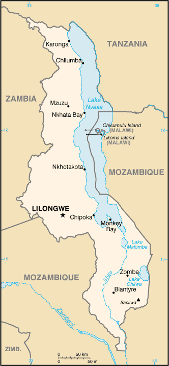
168 mwmztz historically intermittent tricountry conjunction originally as 1886degbpt1919 which was adjusted some 500m southward to present position in 1907 restored to trinational status in 1961 by independence of tanganyika before devolving to present political composition in 1975 situated in the center presumably of the mouth of the txuinde aka chiuindi aka kwindi stream on the east shore of lake nyasa in about n11d34m30 per ibs & brownlie but in recent decades tanzania has been claiming & using the eastern half of the lake north of that latitude & malawi has not been resisting or protesting & so the effective longitude has become roughly 34e37
ibs 37 39 112
malawi mozambique zambia
169 mwmzzm tricountry point since independence of malawi in 1964 reaching present political format in 1975 after inheriting binational administrative trijunction created & delimited in 1891 & marked by 1904 gbpt beacon 38 nominally where s14 crosses the nyasa zambezi watershed divide tho actually a few seconds north of that latitude & at about e33d14m30s wgs84 just sw of village of coumba mw
malawi tanzania zambia
170 mwtzzm tricountry point since independence of malawi in 1964 succeeding british & earlier anglo german administrative trijunction created evidently in 1891 & marked at summit of nankungulu hill elev1949m in roughly s9d24m0s6 e32d57m34s8 wgs84 by 1898 degb pillar 2 & pillar b588 of an unknown demarcation of tzzm probably british 1953
mozambique swaziland south africa north
171 mzszzan tricountry point since independence of south africa in 1961 devolved to present political format in 1975 succeeding binational tristate point established by british arrangement in 1884 pursuant to 1869 gbpt accord & first marked in 1894 by mpundweni beacon aka gbpt pillar 1 which was reaffirmed in 1927 after being topped in 1925 by reinforced masonry capstone now eroding & exposed at apex in roughly s25d57m9s e31d58m30 wgs84 at elev791m
ibs 133 135 137
mozambique swaziland south africa south
172 mzszzas tricountry conjunction since independence of south africa in 1961 reaching present political composition in 1975 succeeding binational tristate convergence established notionally by multilateral agreement in 1888 & promoted by gbpt accord of 1891 & finally proclaimed by great britain in 1895 at intersection of the course of the great usutu aka maputo river & hence its median line hypothetically with the ridge line of the lebombo mountains near abercorn drift in roughly s26d50m25s e32d8m5s wgs84
mozambique south africa zimbabwe
173 mzzazw tricountry conjunction since independence of south africa in 1961 reaching present political composition in 1980 succeeding binational tristate convergence created in 1881 at an uncertain or conflicting position in the confluence of the intermittent rivers pafuri & limpopo in roughly s22d25m30s e31d18m30s
ibs 117 118 133
mozambique zambia zimbabwe
174 mzzmzw tricountry conjunction since independence of zambia in 1964 reaching present political composition in 1980 inheriting somewhat conflicted binational tristate point created by great britain in 1895 pursuant to 1891 gbpt accord & presumably situated at the seasonally variable location of the median junction of the loangwa & zambezi rivers but also in the longitude of 1911 gbpt beacon 1 specified as e30d25m20s3 in an unknown datum which is standing evidently several hundred meters below or east of the median junction on the south bank in roughly s15d37m30s
ibs 30 114 118
namibia zambia zimbabwe
000 nazmzw tho it flies in the face of both common perception & governmental assertion nevertheless the existence of a nazmzw trijunction produced by conflicting de jure boundaries & the resulting territorial overlap not only cannot be ruled out but actually is depicted by best available mapping at a location near the middle of the kazungula ferry crossing in very roughly s17d47m35s e25d15m50s & is thus included in the registry tho not enumerated in the inventory pending further clarification
for maps photos & other data see also bwnazm bwnazw & bwzmzw above
ibs 30 123
while it is perhaps noteworthy that the probability of a precise bwnazmzw quadripoint is practically nil nevertheless bwzm & nazw delimitations do not exist nor have any definite tripoint positions been published if they have indeed ever been agreed
chad niger nigeria
175 nengtd tricountry conjunction since independence of niger in 1960 as frgbne initially but devolving to gbnetd & present form in same year succeeding binational tricolonial convergency created by french military convention in 1912 pursuant to 1906 frgb accord but only loosely delimited & unmarked on the now dry bed of lake chad in roughly 13n43 13e38 subject to minor unresolved discrepancies in the coordinates cited by sources
ibs 73 90 93
oman saudi arabia yemen
176 omsaye ancient multiple frontier of separation in empty quarter of arabian desert emerging as tricountry conjunction on breakup of ottoman empire in 1918 winnowed to tripoint by 3 successive bilateral agreements concluded between 1990 & 2000 with presumably trilateral demarcation circa2005 at n19 e52 wgs84 just about exactly or so it seems
poland slovakia ukraine
177 plskua tricountry point at ridge junction on kremenec summit elev1221m in roughly 49n5 22e34 since cession of ruthenia from czechoslovakia to the soviet union in 1945 devolved to present form by czech breakup in 1993 succeeding binational tristate point of poland with czech ruthenia & slovakia dating from 1919 but actually also inheriting that of galicia & the hungarian counties of zemplen & ung dating possibly from the 11th century is marked by a late 20th century monument which looks difficult to climb
ibs 77
rwanda tanzania uganda
178 rwtzug somewhat indefinite or irrational tricountry conjunction since independence of tanganyika in 1961 reaching present political form in 1964 on its union with zanzibar evidently situated within or very near confluence of kagitumba & kagera rivers as successor to 1916 anglo belgian & earlier anglo german administrative trijunction which was notional from 1885 subdivision of german east africa & increasingly real from 1890 & 1910 degb delimitations albeit displaced between 1921 & 1924 to a nearby location for an abortive railway project but otherwise located in roughly 1s4 30e28 at thalweg junction of kagitumba & kagera per brownlie & ibru following a 1934 begb accord that actually changed the boundary alignment in the upper kagera from the midstream to the thalweg tho it was missed by the ibs studies cited below
& yet owing to the peculiar configuration of the confluence the tripoint as thus redefined appears to fall 100 meters or more below the mouth of the kagitumba as suggested by the pointer on this aerial photo http://bit.ly/c3QqFd so it is quite possible that the point on the kagera thalweg opposite the left side of the kagitumba mouth which coincides with the traditionally accepted trijunction location mentioned by the ibs could yet emerge as tripoint by default
ibs 54 55 69
serbia rs
south africa za
spain es
switzerland ch
united arab emirates ae
united kingdom gb
western sahara eh below